The National Weather Service in Jackson has issued a

* Severe Thunderstorm Warning for...
Northwestern Holmes County in central Mississippi...
Southeastern Washington County in northwestern Mississippi...
Humphreys County in central Mississippi...
Northern Sharkey County in west central Mississippi...

* Until 345 PM CDT.

* At 250 PM CDT, a severe thunderstorm was located over Nitta Yuma,
or 8 miles north of Rolling Fork, moving east at 35 mph.

HAZARD...60 mph wind gusts and quarter size hail.

SOURCE...Radar indicated.

IMPACT...Hail damage to vehicles is expected. Expect wind damage
to roofs, siding, and trees.

* This severe thunderstorm will be near...
Delta City and Murphy around 255 PM CDT.
Louise and Midnight around 305 PM CDT.
Belzoni and Silver City around 315 PM CDT.

PRECAUTIONARY/PREPAREDNESS ACTIONS...

For your protection move to an interior room on the lowest floor of a
building.

&&


HAIL THREAT...RADAR INDICATED;
MAX HAIL SIZE...1.00 IN;
WIND THREAT...RADAR INDICATED;
MAX WIND GUST...60 MPH
The National Weather Service in Jackson has issued a
* Flash Flood Warning for...
Northeastern East Carroll Parish in northeastern Louisiana...
Southern Washington County in northwestern Mississippi...
Northwestern Issaquena County in west central Mississippi...
Northern Sharkey County in west central Mississippi...
* Until 545 PM CDT.
* At 243 PM CDT, Doppler radar indicated thunderstorms producing
heavy rain across the warned area. Between 1 and 3 inches of rain
have fallen. Additional rainfall amounts of 1 to 2 inches are
possible in the warned area. Flash flooding is ongoing or expected
to begin shortly.
HAZARD...Flash flooding caused by thunderstorms.
SOURCE...Radar.
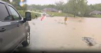
IMPACT...Flash flooding of small creeks and streams, urban
areas, highways, streets and underpasses as well as
other poor drainage and low-lying areas.
* Some locations that will experience flash flooding include...
Hollandale, Rolling Fork, Mayersville, Anguilla, Glen Allan,
Panther Burn, Grace, Delta City, Nitta Yuma, Estill, Avon,
Darlove, Murphy and Shelburn.
PRECAUTIONARY/PREPAREDNESS ACTIONS...
Turn around, don't drown when encountering flooded roads. Most flood
deaths occur in vehicles.
&&
FLASH FLOOD...RADAR INDICATED
...STRONG THUNDERSTORMS WILL IMPACT SOUTHEASTERN CHICOT COUNTY...
NORTHEASTERN EAST CARROLL AND NORTHEASTERN WEST CARROLL PARISHES...
SOUTHWESTERN SUNFLOWER...SOUTHERN WASHINGTON...NORTHWESTERN
ISSAQUENA...WESTERN HUMPHREYS AND NORTHERN SHARKEY COUNTIES THROUGH
330 PM CDT...

At 225 PM CDT, Doppler radar was tracking a cluster of strong
thunderstorms near Glen Allan, or 9 miles southwest of Hollandale,
moving east at 35 mph.

HAZARD...Wind gusts up to 50 mph.

SOURCE...Radar indicated.

IMPACT...Gusty winds could knock down tree limbs and blow around
unsecured objects.

This strong thunderstorm will be near...
Hollandale, Panther Burn, Nitta Yuma, and Estill around 230 PM
CDT.
Delta City around 235 PM CDT.
Darlove around 240 PM CDT.
Murphy around 245 PM CDT.

PRECAUTIONARY/PREPAREDNESS ACTIONS...

If outdoors, consider seeking shelter inside a building.

Torrential rainfall is also occurring with this storm and may lead to
localized flooding. Do not drive your vehicle through flooded
roadways.

&&


MAX HAIL SIZE...0.00 IN;
MAX WIND GUST...50 MPH